Tidal Waves & Under-Sea Land Slides that destroyed regions of ancient Tamil Nadu & the first two Tamil Sangams
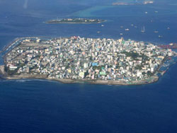
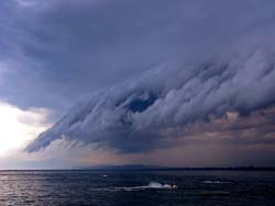
We all have witnessed during our life time the large destructive Tidal Waves which are known today as the Tsunami (a Japanese Language word meaning "Harbour Waves") hitting the shores of Tamil Nadu and Sri Lanka, in addition to many other South and South-East Asian Countries on the 26th December 2005.
(1) Causes of "Tidal Waves"(Tsunami)
The "Tidal Waves" (Tsunami) are a series of destructive sea waves that moves across the ocean, generated by large and violent Earthquakes (i.e. Vibrations or Tremors) occuring beneath the sea.
These Earthquakes are due to sudden dislocation of the segments of the earth's crust, resulting from the under sea volcanic eruptions (i.e.molten rocks eruptions).
(2) Causes of "Under-Sea Land Slides"(Submarine Avalanches)
The "Under-Sea Landslides" (Submarine Avalanche) are falling or sliding of large masses of the mixture of - soil, rock, and other earth materials from outside the surface of the sea, rapidly into the sea under the force of gravity.
The seabeds wherever the offshore slopes dip steeply enough pose the threat of "Under-Sea Landslides", and sometimes may not even require Earthquakes to touch them off.
They are capable of generating deadly Tsunamis as the surface of the ocean first recedes and then surges forward to crash against the shores.
(3) References to "Tidal Waves" & "Under-Sea Land Slides" in early Tamil Literary Works
From the earliest Tamil literary works belonging to the first and second century Tamil Nadu, namely Iraiyanaar Ahapporul, Kaliththohai, Silappathikaaram, and Manimehalai, we come to know that in the ancient times too there had been massive Tidal Waves which have hit the shores of the Paandiya (Pandiya) country and the Chola country of the then Tamil Nadu of South India, causing very big damages and heavy losses.
At times there have been very ferrocious Tidal Waves that have hit Tamil Nadu, and large areas of the seaside lands and the lands much interior have submerged into the ocean, possibly due to big "Under-Sea Land Slides".
(4) The first known "Under-Sea Land Slides" that affected Tamil Nadu and the First Tamil Sangam
The Paandiya Country of the then Tamil Nadu of South India, had it's capital city in the inland known as the "Adakak Kudumi Maadak Koodal" which means: the Koodal (city) with buildings having golden spires.
Mathurai was the other name of this city of Koodal. It was at this Koodal (or Mathurai) city of the Paandiya country, the first Tamil Sangam (a Tamil Academy) with many Tamil Poets fostering the growth and development of the Tamil Language & Literature under the patronage of the Paandiya kings, was instituted and conducted for many years.
The city of Koodal or "Thenmathurai" being the location of the first Thamil Sangam is confirmed by the follows:
“……Adahak Kudumi Maadak Koodalin munnarach Sangakk kanmaa palahaiyil ……thinthirat pulamai kundihaik kurumuni, puvipuhal maruthang kaviniya Muranjip pathi Mudi nahanithiyin kilavan……”
“……..Muthal Uli iruthiyk kan Then Mathurai yahaththu thalaich sangaththu Ahathithiyanaarrum, Muranjiyoor Mudinagaraayarum…..”
[i]which means: ".....in front of the Koodal with golden spires on the palahai (seat) of the Sangam office, the world famed poet with sweet compositions the sage Mudinaganithi of the Muranji centre......"
"........in the Uli the Agathiyaaar and Muranjiyoor Mudinagaraayarum.......[/u]"
Silappathikaram - Page 7-8 (U.V.Saminatha Iyer's Edition). Poem found in an old Ola Leaf Manuscript in the house of Sevvur Sittrampalak Kavirayer included in this edition.
It was during the first Tamil Sangam period the ferrocious Tidal Waves of the Sea of a very great magnitude, have hit and destroyed the coastel and far inland areas of the Paandiya country, most possibly due to a very massive Under-Sea Land Slide which sank a very large land mass with many countries, range of mountains, rivers, and forests far south of the present Kumari region (in the south) which all went under sea.
This fact is testified by “Adiyaarkku Nallaar” in his commentry to the Tamil Epic the Silappathikaram, which provides further informations on same as follows:
"......Ak kaalaththu ‘avar naattuth’ Thenpaali mukaththitkku vada ellaiyahiya Pahtruli ennum aartritkum Kumari ennum aartritkum idaiye elunoortru kaavatha vaarum ivattrin neer malivaanena malintha Earl Thenga naadum, Earl Mathurai naadum, Earl Munpaalai Naadum, Earl Pinpaalai Nadum, Earl Kuntra Naadum, Earl Kuna Kaarai Naadum, Earl Kurumpanai Naadum ennum naatpaththu onpathu naadum, Kumari Kollam muthaliya panmalai naadum, kaadum, nathiyum, pathiyum, thadaneer Kumari Vadaperum Kottin ‘karum kadal kondolithalat’ Kumariyahiya Pauvam entru unarha....."
which means: "....In those days between the Thenpaalimukam (southern “seawater” front) of his (Pandiyan's) country, and the northern boundry being the Pahtruli river and the Kumari river, there had been 700 hundred Kaavatham distance and in between which there were forty nine countries, (named) the Earl(seven) ThengaNadu, Earl(seven) Mathurai Nadu, Earl(seven) Munpaalai Naadu, Earl(seven) Kuntra Nadu, Earl(seven) Kunakaarai Nadu, Earl(seven) Kurumpanai Nadu, the country known as Kumarik Kollam of many mountains, the forests, rivers, cities, upto (but not) the northern big mountain range of Kumarik Kodu - were swallowed by the sea......"
Silappathikaram - Puhar Kandam, Venit Kaathai, Page 228
(U.V.Saminatha Iyer's Edition)
From the above reference it is very clear that there had been a large land mass of about 700 Kavatham distance (1750 miles) covering forty nine countries and a region called Kumari Kollam in between the northen mountain range of this landmass known as Kumarik Kodu and its far southern “seawater” front (Thenpaalimugam), having many mountains, forests, rivers and cities.
From same it appears the region just south of Kumarik Kodu was a region called the Kumarik Kollam. In the south of this region have been the Pahruli river, and the Kumari River was close beyond the Pahruli river in it’s south.
In the above reference it is confirmed that these two rivers were the northern boundries of the lost large land mass. It also appears the next two regions beyond Kumarik Kollam would have been the Earl Thenganaadu & Earl Mathurai Nadu.
It appears the Kumarikkodu mountain range and the Pahtruli river escaped this sea disaster while the Kumari river with the major part of Kumari Kollam and the entire land mass south with forty nine countries went under sea. Among these countries which went under sea was the “Earl Mathurai Nadu” which is undoubtedly the "Then Mathurai" (Southern Mathurai) the capital city of the early Pandiya kings which comprised the first Thamil Sangam of the Pandiya country.
This first known Sea destruction cannot be simply estimated as a Tsunami that we have witnessed during our life time. But it appears to be a vast and massive "Under Sea Land Slide - a Submarine Avalanche covering approximately 1750 miles in the southernly direction beyond the the Kumarik Kodu and Pahtruli river gradually sliding into the sea. This is probably the vast landmass the modern Geological Scientists refer to as “Lost Lemuria” or “Kumari Kandam” which was submerged in the sea.
It also appears the great land mass beyond present Kanyakumari district was probably embracing the present Sri Lanka too within, and with this massive "Under-Sea Land Slide" in the south of India it was seperated from the remaining Indian Mainland.
This could be a definite possibility as “Sivatharumoththaram” says at the foot of the Mahendra mountain was the Illankai thesam and that give us a clue that the Mahendra Mountain range extended beyond the present Kanyakumari region along the west of the present Sri Lanka and the Illangai Thesam was on the east of the Mahendra Mountain range at its foot hills which submerged in to the sea leaving back Sri Lanka.
This destruction would have taken place long before the period of the epic story Ramayana. This is confirmed by the reference in the Valmiki Ramayana that the Mahendra mountain range of the then Kumarik Kodu remained almost fully submerged into the sea at the time of Ramayana epic, and only a peak of this range remained on the outside surface during the time of this epic story, and continues to remain even today known as the Mahendragiri (or Mahendra Malai) in the present Kanyakumari district of Tamil Nadu.
This is confirmed by the Valmiki Ramayana as follows.
".......agastyena antare tatra saagare viniveshitaH |
citra saanu nagaH shriimaan mahendraH parvatottamaH || 4-41-20
jaata ruupamayaH shriimaan avagaaDho mahaarNavam |
naanaa vidhaiH nagaiH phullaiH lataabhiH ca upashobhitam || 4-41-21
which means: "There, with its one end verily penned in by Sage Agastya inside the ocean, the fortunate Mt. Mahendra is there, with its marvellous pinnacles and the best among the mountains.." [4-41-20] "That august Mt. Mahendra is completely golden penetrating into ocean and it is glorified with numerous kinds of flowered trees and climbers also... [4-41-21]
Valmihi Ramayana - Kishkindha Kanda - Chapter [Sarga] 41
The sinking of the Mahendra Mountain range into sea, and only one peak remaining is further confirmed by Tamil Saiva Saint Thirumaaligai Thevar in his Thiruvisaippa (of the 9th Thirumurai) as,
".....Aluntha Mahendraththu....."
[which means: the Mahendra Mountain (portion) that never sunk]
The survived peak of the Mahendra mountain range could be seen even today, south of Thaamiraparani river in the present Kanyakumari district, almost midway between the Thirukkurungudi and Bhutapandi having a height of 1,654 Metres (5,425 Ft), and presently called as the Mahendragiri. (Giri is mountain - in Sanskrit, and Malai in Tamil)
Further from the commentery of “Adiyaarkku Nallaar” in Silappathikarem referred above, it is clear the northern most region of this large land mass – the Kumarikkodu range of mountains with Kummarik Kollam and the Pahruli river escaped the wrath of the sea, and from the sequential order of the countries listed above immediately after them, it is clear the Pandiyanadu of that period encompassed the Earl Thenga Nadu and the Earl Mathurai Nadu, from where possibly people would have fled more towards the north to the regions of Kumarik Kollam and the Pahruli river.
Hence we can safely infer that with the gradual submerging of Earl Thenga Nadu and Earl Mathurai Nadu, and with the Pahruli river and Kumarikkkodu escaping the wrath of the sea, the Paandiyan king and the first Tamil Sangam Pulavars and other subjects managed to escape further north to Pahruli river and the Kumarikkodu region, which could have been a definite possibility. The Paandiyan king who was ruling during the end of the first Thamil Sangam was the Kadungkoan which is confirmed by the follows :
“….Thalaich Sangamirunthaar……avarkalaich sangamiree iyinaar Kaichchina Valuthi muthalaha Kadungkoan eeraaha enpaththonpathinmar enba……”
Iraiyanaar Ahapporul - Nakkeeeranaar Urai
Published by Bhavanantham Pillai - Mullai Nilayam Publication
From the same source another reference confirms the first Pandiyan king of second Thamil Sangam was Vendherch (Venther) Cheliyan. Hence it is clear the last Paandiyan king of the first Thamil Sangam the Kadungkoan did not survive the tidal waves with undersea landslides.
(5) The second known "Under-Sea Land Slides" that affected Tamil Nadu and the Second Tamil Sangam
With this loss of the large territories of the Pandiya country, the then king Nediyon moved more towards the north and captured many new regions and made them the new Pandiyan regions, and distributed the captured lands to his subjects who met the loss - but possibly escaped this great tragedy, made him get the title "Nilam Tharu Thiruvit Pandiyan" [which mean: "the Pandiyan who made the kind gesture of lands"]
The Paandiyan king now built his new capital at Kapaadapuram (Kavadam). From the reference in the Valmiki Ramayana it is very clear that the Kapaadapuram the new captial city of the Pandiyas was closer to the sea. This is confirmed by the follows:
"......yuktam Kavaatam Paandyaanaam gataa draksyatha Vaanaraah tatah samudram......"
(which means: "...... having reached Kavaatam of Pandiya ongoing you shall see Vaanarah (Oh! Anuman) then ocean...."]
Valmihi Ramayana - Kishkindha Kanda - Chapter (Sarga) 41
This is further confirmed by the follows.
".......maasil vaan munneer parantha thonnilam aalum kilamaiyodu punarnththa enko vaaliyar im malarthalai ulake......"
[which means: (let) our king (long) live in this wide world, who is ruling with the right to rule the speckless sky - wide seafront ancient land]
Mullaikkali in Kalithithohai refers to a Pandiyan.
Hence the 'wide seafront ancient land' could possibly refer to Kapaadapuram]
Kaliththohai - Mullaikkali - 3rd poem
From the above it is clear the second Pandiyan capital Kapaadapuram was closer to the sea some what east of the present Mathurai. The Pandiyan king with a view of preventing further sea disasters had a festival celeberated for the Sea God and hence he was known as "Munneer Vilavu Nediyon" (Munner Vilavu = Sea (God) celeberation) and also as "Vadivalamba nintra Pandiyan".
In this new city of Kapaadapuram the Paandiyan king establised the second Thamil Sangam which is confirmed by the follows.
"......Irandaam Uliyathakiya Kapaadapuraththin Idai Sangam......."
[which means: "the middle (second) Sangam of the Kapaadapuram of second Uli" (Uli – period after great disaster)]
Silappathikaram - Uraipayiram, Adiyaarkku Nallaar Urai Kaathai, Page 6-7 (U.V.Saminatha Iyer's Edition)
".......Idaich Sangam vinnakam paravu methahu keerththik Kannakan parapit Kapaadapuram enba....."
[which means: "the middle (second) Sangam at Kapaadapuram the land of Kannakan (the Pandiyan) of great fame spreading to the heaven"]
Silappathikaram - Page 7, Poem found in an old Ola Manuscript in the house of Sevvur Sittampalak Kavirayer, (U.V.Saminatha Iyer's Edition)
It was in this second Thamil Sangam at Kapaadapuram (during the Ramayana Epic period) the poet Agaththiyar wrote the treatise on Tamil Grammer known as “Agaththiyar Illakkanam” and some time later the poet Tholkaappianar too wrote a treatise on Tamil Grammer named the “Tholkaappiam” in the presence of the Pandiyan Nediyon also known as Nilam Tharu Thiruvit Pandiyan. This is confirmed from the follows:
"......mahathuvamudaiya Agaththiya Illakkanam vaduvaru kaatchi naduvat sangath Agaththiyar Tholkaappiyath Thamil Munivar.......an naal Illakkanam Agaththiyam athanodu pinnaat seitha pirangu Tholkaapiam......"
(which means: "the Naduvar Sangam where the Agaththiya Illakanam of esteem was (staged), to weed off the faults (there the) Agaththiyar and Thokaapiya Thamil sage"
Silappathikaram - Poem found in an old Ola Manuscript in the house of Sevvur Sittampalak Kavirayer, Page 7
(U.V.Saminatha Iyer's Edition)
"........irrandaam Uliyathakiya Kappaadapuraththin idaich Sangaththu Tholkaappiam pulappaduththiya Maakeerthiyaakiya Nilam tharu thiruvit Pandiyan avaikkalaththu Agathiyanaarum, Tholkaappianaarum......???"
[which means: "the middle (second) Sangam of the Kapaadapuram of second Uli where the Nilam tharu thiruvit Pandiyan who brought forth the Tamil Grammer Work the Tholkaappiam, in his auditorium where the Agathiyanaar and Tholkaappianaar were present"
Silappathikaram - Uraipayiram, Adiyaarkku Nallaar Urai Kaathai, Page 7-8
Also include Panambaranar's Paayiram from Tholkaappiam.
“….vada vengadam thenkumari aayidai thamil kurum nalulakaththu….”
“…..Nilam thiruvit Pandiyon avaiyaththu…….”
“….malku neer varaippin iyinthiram niraintha
Tholkaappian enath than peyar thotrip
Palpuhal niruththa padimaiyone….”
This further confirms that Tholkappiam was staged during the time of "Nilan tharu thiruvit Pandiyan"
include Pahruli manalinum palave.
The above was sung by Panambaranar who lived during the time of Netimaiyar. ?????????
Many years after the period of the Ramayana Epic the destructive waves of the sea, again destroyed the Pandiyan capital, on this occasion the Kapaadapuram with the second Thamil Sangam.
This too would have been the destructive fierce Tidal Waves resulting again from a big Under-Sea Land Slides, with the destruction of the Paandiya country with the Paandiyan capital Kapaadapuram with the river Pahruli and some adjoing lands along the coastel regions and the Kumari Range of Mountains (Kumarkikodu) went under sea.
This fact is testified in the great Tamil epic the Silappathikaram as follows:
".........Pahtruli arttrudan pan Malai adukkaththuk Kumarik Kodum kodung kadal kolla
vada thisaik Gangaiyum Imayamum kondu then thisai aanda Thennavan vaali......."
(which means: "....long live the Pandiyan [who, when] the Pahtruli river and the many ranges of mountains of the Kumarik Kodu was swallowed up by the fierce sea, captured the the Ganges [river] and the Himalayas of the north and ruled the south ")
Silappathikaram - Madurai Kandam, Kaadu Kaan Kaathai, Line 19-22, Page 289
(U.V.Saminatha Iyer's Edition)
This is further confirmed by another Sangam period Tamil Literary work Kaliththohai which states as follows.
".....Mali thirai oornthu than mann kadal vowvalin melivintri metsentru mewaar naadu idampadap puliyodu vil neekkip puhal priththa kilar kendai valiyinaal vanakkiya vaadaar seer thenavan....."
(which means: when the sea with many waves rolled and swallowed his lands without depression went further captured the countries of those not subdued to him, removing the tiger and bow flags establised the fame of the kendai (fish) made to worship by his valour the Thennavan of unfading fame)
Kaliththohai - Mullaikkali - 4th poem
Panambaranar ref re Sea tide
(6) The building of the Third capital city and establishment of the third Tamil Sangam by Pandiyan king
It was probably after that the Paandiyans realised the gravity of the natural disasters and built the new capital much interior in the central region of lower South India far away from the sea also known as Mathurai, apparently the present Mathurai where they held the third Thamil Sangam.
As this was the new city of the Paandiyas where the third Thamil Sangam was established bearing the same name as the city where the first Thamil Sangam functioned earlier in the lands in the south which have now submerged into the sea, the Mathurai of the third Thamil Sangam was referred to as the Vada Mathurai (Northern Mathurai) during that period.
This is confirmed by the following:
".....Arung Kadaich Sangam irunthor........puviyit Sangam puhal Vada Mathurai......"
(which means: who were in the unique last (third) Sangam......in this earth the Sangam famed northern Mathurai)
Silappathikaram - Poem found in an old Ola Manuscript in the house of Sevvur Sittampalak Kavirayer, Page 8
(U.V.Saminatha Iyer's Edition)
During the period the Pandiyas establised the third Tamil Sangam at the new Mathurai in the central region of southern India, the Cholas had their capital at Kaviripoompattinam also known as Poompuhar.
(7) The Tidal Waves that affected the Chola capital Kaviripoompattinam of Tamil Nadu
The God Indra was known in Tamil Nadu as the god of ocean during the Ramayana days and the legend holds that God Indra visited on auspiciou days the Kumari region where the Mount Mahendra is situated which is confirmed by the following statement in the Ramayana.
"......tam upaiti sahasraaksah sadaa parvasu parvasu |
dviipah tasya apare paare shata yojana visritah ||...... " 4-41-23
(which means: "The Thousand-eyed Indra always reaches that Mt. Mahendra on every auspicious day... and the other shore is an island with a breadth of hundred yojana-s")
Valmihi Ramayana - Kishkindha Kanda - Chapter [Sarga] 41
The Cholas probably realising the gravity of the sea tides from the experiences of the Paandiya Naadu yearly had a great festival for fourteen days worshiping the ocean god Indra as Indra Vilaa at the ocean front where the Kaveri river joined the sea and where they had built their capital city the Kaviripoompatinam.
The people of Kavirimpoompattinam believed that if the Indra Villa festival is defaulted that they had to meet the wrath of Bootham hence the festival should be conducted.
".......viduththa bootham vilaakkon marappin madiththa sevvaai val eyiri ilanga Idikuran mulakkaththu thedumbai seithidum thoduththa paasaththu tholpathinarakarai pudaiththunnum porunthathaayidum......."
Manimehalai - Villavarai Kaathai , Lines 20-26 Page 13 &14 (U.V.Saminatha Iyer Edition)
From the Silappathikarem we note after the tragedy and death of the heroine Kannahi (Paththini) the Chola kings defaulted in conducting the annual seafront festival to God Indira. This resulted in the Kaviripoompattinam also known as Poompuhar having to face the fierce Tidal Waves of the sea which destroyed this seaport city.
"......Kavirip Pattinam kadal kolu entru thavaththu urai kettu....."
Manimekalai - Kachchimaanahar pukka Kaathai - 28 Line 135-136
".......manangkaval keduththathu Manahar kadal kolla Aravanaadikalum Thayarum aangu vittu irrava ipPathi puhunthathu......."
Manimekalai - Kachchimaanahar pukka Kaathai - 28 Line 80-83
"......Vaanavan vilakkoan maanagar olinthathu Mamimekalatheivam mattrathu poraal anninagar thannai alai kadal kolha ena vittanal saabam patta ithuvat kadavun Managar Kadal kolla peyarntha vadivet thadakkai vaanavan pola virithirai vanthu viyannager vilunga oru thani poyinan ulaka mannavan......"
Manimehalai - Aapuththiranodu Manipallvam adaintha kaathai - 25 page 289 Line 197-204
"Thivaka Santhi Seyya naalun Kaavan Ma nagar Kadal vayiru pukoom Manimekali than vaaimoli yaalathu thaniyaa Indra saabam undaakalin aangu pathiyalithalum eengu pathi keduthalum ventharai yatoi meyena kondik kaasin managar kadal vayiru puhaamal vaasavan vilaa kon maravel"
Manimehalai - Aapuththiranodu Manipallvam adaintha kaathai - 25 page 289 Line 63-69
"Vinnavar Thalaivanai vananki munintru mannaha thentran vaanpathi thannul
meloar vilaiya vilakkol eduththa naal earl naalilum nankinithuraikkena amarar thalaivan aangathu nernthathu"
Manimehalai - Vilaavarai kaathai - 12 page 289 Line 5-9
Thanks: Mayam.com
Indus valley dravidian civilization